
November 24th, 2015 – HIGH ALERT FOR TERRORISM
As we approach Thanksgiving and the associated Shopping extravaganzas which roll into the holiday season we are reminded that there are active however non-specific threats against the United States by ISIS. We must be ever diligent in our daily activities and be on the look out for suspicious situations. Additionally we must be prepared as we would in any emergency to fend for ourselves for an extended period of time. Why must we be prepared – in a situations of domestic terrorism there may be interruptions or restrictions on travel, financial transactions, and communications which will affect things such as food and fuel deliveries. If our communication infrastructure is compromised then things we daily count on such as debit and credit card transactions cannot take place so having necessary funds on hand should be part of your preparation. While there are companies out there that sell “survival food” kits that contain everything you need it might be more affordable to simply purchase a few extra cans of soup or stew when you go shopping. Also grab some of the non-refrigerated or dry milk and cases of bottled water. If you do this every week or so after a while you should have a good stock pile of food for an emergency. Take advantage of special sales such as 10 for 10 or case pricing sales. Remember these items have a best use by date on them which you want use to rotate through your stock so that you know what to use first. Get into refueling your vehicle when the tank goes below 3/4’s of a tank – it doesn’t cost you any more except a few extra minutes of your time and will assure you that you have a full tank of fuel if something was to happen. Diligence and preparation work together when you start forming habits such as illustrated above keeping your vehicle fueled and purchasing extra store-able food and then further continue to when you enter a place of public assembly you are looking for that unattended package or people that are acting suspiciously or look out of place such as wearing an overcoat in warm weather to conceal an explosive device. Lastly, as with Crime Watch you have call in suspicious activities so that local police can investigate the situation you must do the same with suspicious activities that might be associated with terrorism and call the police. REMEMBER “If you see something, Say something”

November 11, 2015 – Code Red explained
After each rain or flood event City Government members, OEM, and the Police Department get phone calls asking why they didn’t get a call. A little background first – In recent years many residents have gotten rid of their traditional hard lined phone and replaced them with cellular phones. To many this make financial sense. With more and more cellular phones replacing traditional phones this is one of the reasons why enhanced 9-1-1 has been introduced several years ago. Enhanced 9-1-1 provides coordinates from your cell phones GPS so that in addition to your number the 9-1-1 answering point has a general idea where you are. How does that affect the way North Wildwood notifies it residents? North Wildwood uses CODE RED Emergency Communications System or shorten to CODE RED ECS as the platform to notify residents. Code Red ECS is regularly updated with all the hard line Verizon and Comcast phone numbers. (Not Verizon wireless only Verizon regular home phone lines) As the phone numbers cannot be seen by the end user (North Wildwood) they include all unlisted numbers as well. CODE RED ECS is a geographic based application – that is all messages are comprised of two main parts – message and audience. That is specific messages only go to people living in a specific area (more will be explained further on this page) so if you live on Atlantic Avenue you won’t get a flood messages that is aimed for people on Delaware Avenue.
How does it work – The CODE RED ECS lead agency is the Office of Emergency Management with the Police and Fire Departments having authorized persons to create and send messages. To expedite notifications there are several messages that have been created and saved in the system. These are ones used on a regular basis such as tidal flood warnings, rain flooding warnings, and snow emergency route notice. I will explain those further in a few minutes – first back to how to get a message. If all you have is a Verizon or Comcast hard line phone you have to do nothing. However if you have only a cellular phone or have a cellular phone in addition to your regular phone you can click on the top link on the right hand side of this page and add as many phone numbers you wish to your address and you can also sign up for text and email messages as well as TTY messages. Coming by the first of the year these messages will be going out on the OEM Facebook and Twitter accounts. Remember it is the decision of the person creating the message to create the secondary messages such as Text, TTY, or Email so all messages may not go out to all communication methods that you signed up for. Now that you are signed up what you expect will be explained next.
City wide CODE RED ECS Messages – City wide messages are reserved for the situations that may affect all residents such Major storm warnings and Evacuation notices. No need to show a map this is everyone that has signed up or is in the system. There are no canned messages at this time. Messages are reflected upon and created for each event.
Advance Flood Warning (No Siren) and Flood Warning (Siren) Messages – These messages are for tidal flooding. The OEM weather station has a tide gauge (click on the third link from the bottom on the right hand side this page) that we use to be able to predict when flooding will occur. When the gauge gets to 6.2 feet we start to see water at the curb at some areas of Delaware Avenue. We next take into consideration wind direction and time to the predicted high tide and make a decision whether to send a message or not. If it is just before high tide when the gauge is at 6.2 feet we generally do not send the messages. That is why occasionally you will see water in the gutters of some streets without being notified. We urge you to check the tide gauge when you have tidal street flooding so you can have an idea of how the different heights affect your house directly. For example you have water up to the bottom of your front step and you checked the gauge at it shows 7.2 feet you know when the tide is predicted to be 7 – 7.5 feet you have an idea how your property will be affected. If you live in the area of the map that is in Red you will be notified with the flood warning messages.
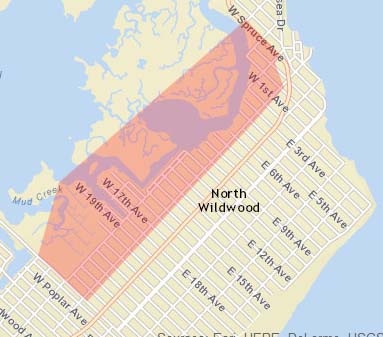
Rain Water Flooding – This message is for use during heavy rain which overwhelm the storm sewer drainage system. Many people think that the water going down the sewer near the corner of your street enters an underground sewer pipe takes the water away. Wrong – North Wildwood utilizes a “bubblier system” that is water goes down the sewer on the East side of a North/South Street (for example New York Avenue) and bubbles up on the West side of the North/South street to travel along the curb until it reaches the next North/South Street and then it travels under the and up next North/South street until it reaches the outfall pipe at the bayside. To prevent tidal flooding the outfall pipes have flapper valves on them that allow water out but prevent water from coming in during high tides therefore when it rains hard during high tide rain water will encounter a flapper valves that is closed thus rain water will drain off slower. If you live in the area of the map that is in Red you will be notified with the rain water flood warning message.
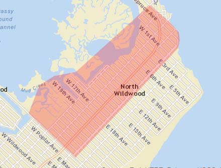
Snow Emergency Routes – North Wildwood has two snow emergency routes when snow covered cars must be removed to enable curb to curb plowing. These routes have Snow Emergency signs posted on them. In the event that a predicted snow storm is coming the message will be sent to all people on Atlantic and New Jersey Avenues. Your cooperation is requested to keep these routes open during snow storms. If you live in the area of the map that is in Red you will be notified with the snow emergency route message.
Other Emergency Messages – What other messages can I expect? The list is unlimited however for example if there was a natural gas leak or chemical spill and we needed to notify nearby residents to close their windows the Fire Department would create a Circle around the incident location and then create a message for that audience to warn them about the situation and provide specific instructions. All people registered in the circled area will be notified. If there were an area of town that experienced automobiles being broken into the Police could send a message to residents in that specific area to lock their cars and report strangers.
Remember – All messages are address based so there is NO actual “list” to sign up for. You can not sign up for flood messages if you don’t live in flood areas it is based on your address. If you have a summer house you can add your out of town phone numbers to your address using the CODE RED ECS link on the right hand column. TIP – when you add your cell numbers and email addresses at the CODE RED ECS website create an account so that you can go back and add additional numbers or delete numbers. Remember – even though these are emergency messages when you sign up you are responsible for any fees that your cell service charges for text or phone messages. There is no charge for signing up for CODE RED ECS messages.
October 28, 2015 – Accept our Apologies for the Wrong Message
This morning high tide (9:00am) and probably during tonight’s high tide (9:27am) we are expecting minor tidal flooding which should encompass most of Delaware Avenue and portions of New York Avenue (around 5 to 9th Avenues). This morning for some reason the message for the Nor’easter and Hurricane Joaquin went out instead of the normal initial flood warning message. When the error was discovered we were able cancel the message after about 2/3’s of the numbers were dialed. Then the correct message with a notation to disregard the previous message about Hurricane Joaquin was sent to the normal recipients that live on the west side of town. A short while later was realized that the first message was a city wide message as opposed to one that goes to the frequent flooded area and a subsequent disregard and apology message went out city wide. It is uncertain whether the sending of the wrong message was a glitch in the system or human error. The launching of a message involves multi-agencies however the Office of Emergency Management accepts full responsibility for the error and apologies for the sending of the wrong message. Steps have been taken so that the likelihood of this happening again is minimal. We would like to thank those that called either the Police or Emergency Management to report that the wrong message was sent. If you did not get a message and felt you should, you can click on the top link on the right hand column and sign up for the Code Red Emergency Notifications.
October 8, 2015 Nor’easter Numbers and a New Link
Today on the right hand side under IMPORTANT LINKS is a new link called NWS EMERGENCY MANAGER BRIEFING has been added. The link will take you to a .pdf document that the is the latest briefing for Emergency Managers. This is a comprehensive weather report for our use in alerting the public and making plans. Only in the case of a prolonged event will there be a briefing and the last briefing will stay there until the next briefing. Therefore when you click on it today you will see the briefing from October 3rd and it will stay there, sometimes for months, until the next storm comes. Note the document name stays the same it is simply replaced by the the new briefing. We put this on the website to give you an insight into what we do and what data we are working from. In the interest of self reliance we provide these links so you can make intelligent decisions on your own.
Weather station data – For those that live in the area of town that gets regular tidal flooding and follow it by checking the North Wildwood tide gauge (see right hand side links) we have downloaded data from the storm and posted it below. For your understanding tidal flooding depends several things both water level, wind speed and direction so when the water reaches a specific level it may or may not flood always. Generally we notice water starts to appear at some Delaware Avenue locations when the level gets to 6.2 feet. If it gets to 6.2 feet an hour before high tide then we know that the likelihood of substantial water in the street is eminent and we start warning process. Also the tide usually continues to rise up to an hour past the predicted high tide time. Below is a list of high tide levels and the time it was the highest during the storm period and the predicted high tide time. Remember you should make note of where the water came up on your property at a specific high tide and keep it for future reference.
Day/Date – Tide – Predicted Time – Actual Tide – Actual Time
Wed 09/30 High 10:11 AM 6.44 Feet 10:51 AM
Wed 09/30 High 10:37 PM 5.92 Feet 11:17 PM
Thu 10/01 High 11:03 AM 7.32 Feet 12:21 PM
Thu 10/01 High 11:32 PM 7.15 Feet 1:06 AM
Fri 10/02 High 11:58 AM 8.14 Feet 1:12 PM
Sat 10/03 High 12:30 AM 7.78 Feet 1:48 AM
Sat 10/03 High 12:56 PM 7.86 Feet 2:06 PM
Sun 10/01 High 1:33 AM 7.21 Feet 2:36 AM
Sun 10/01 High 1:59 PM 7.48 Feet 3:16 PM
Mon 10/01 High 2:40 AM 6.51 Feet 3:24 AM
Mon 10/01 High 3:05 PM 6.65 Feet 3:46 PM
October 2, 2015 – NO WAKE ZONE
A new phenomenon has emerged with people riding their cars through the water covered roads. I am not sure that this started when they started leasing cars but you ought to know that salt water is far more corrosive than fresh water. Due to crowns in the road and other imperfections it is often hard to judge the depth of the water. During the recent storm the water in the 1100 block of Delaware Avenue was about two foot on the crown (center of road) and probably by the curb you could add another foot. Every storm we have to rescue someone who drove in water too deep and stalled and could not start their car. One thing everyone should remember when you see that “rooster tail” shooting six foot in the sky on the outside of your tire a opposite “rooster tail” is shooting upward on the inside of the tire forcing water in every nook and cranny of the engine compartment and undercarriage area. In about six months when your car starts making noises you’ll know why. Also you have to consider all the damages that are caused to flower beds, garage doors and other lawn ornaments. Remember when you see water in the street turn around and take another route – there are alternatives besides that you can by summonsed for traveling on water closed streets. Why jeopardize yourself and others.
October 2, 2015 – Nor’easter
As we end the summer season without an major weather events we now have to prepare for Hurricane Joaquin and a un-named Nor’easter caused by a stalled front in the North Atlantic. As of today Hurricane Joaquin seems to be a lesser threat with the path heading more easterly and out to sea. The real threat is the Nor’easter. The winds have been blowing out the North East for about 10 days and it has created higher than normal tides. With the winds picking up with the front passing through on Thursday brought tides of 7.35 feet. This caused flooding on some areas of New York Avenue around Seventh Avenue and on Delaware Avenue. As you could see if you checked the North Wildwood weather station tide gauge the tide did not go all the way down to the normal low tide height. Today (Friday) the tide around 1 PM was 8.14 feet which caused moderate flooding. All except a few blocks of New York Avenue were flooded as was all of Delaware Avenue and North Delaware Avenue, Spruce Avenue was flooded and traffic was diverted to Anglesea Drive. New Jersey had water in gutters and in some sections out to the drive lane on both sides. The Entertainment District was flooded and near the Elks on the NJ Avenue connector water was across the roadway being several inches deep at the crown. At this point preliminary predictions from the National Weather Service issued today at 12 Noon shows the next four high tides to be in excess of 8 foot. Tides are wind driven and at low tide the water has not receded from the streets. This could affect the future tides for the worst. The difference with a Nor’easter and a hurricane – the Hurricane is moving and when it passes the winds shift bringing the tide out (or in) while a Nor’easter will last for days and compound to a larger event.
Often the National Weather Service will forecast minor, moderate or major flooding to bring this in prospective I found a NOAA document that shows tide heights for various storms at different locations. Below is a portion of that document which uses the tide gauge at the Cape May Ferry Terminal as the reference tide gauge:
THE PERIOD OF RECORD FOR THE CAPE MAY GAUGE BEGINS IN DECEMBER 1965. PLEASE NOTE THAT THERE ARE GAPS WITHIN THE PERIOD OF RECORD DUE TO EQUIPMENT OUTAGES AND/OR DATA AVAILABILITY.
ALL HEIGHTS ARE IN MEAN LOWER LOW WATER (MLLW).
8.9 FT — October 29, 2012 (Post Tropical Cyclone Sandy).
8.8 FT — September 27, 1985 (Hurricane Gloria).
8.7 FT — MAJOR TIDAL FLOODING BEGINS.
October 25, 1980.
8.6 FT — December 11, 1992.
8.5 FT — January 4, 1992 / March 3, 1994.
8.4 FT — August 27, 2011 (Hurricane Irene).
8.3 FT — October 14, 1977.
8.2 FT — December 22, 1972 / October 31, 1991 / February 5, 1998 / June 4, 2012.
8.1 FT — March 29, 1984 / October 17, 2009 / November 13, 2009.
8.0 FT — January 28, 1998 / October 7, 2006 / May 12, 2008.
Flooding occurs along Dennis Creek around NJ Route 47 in Dennis Township.
Flooding occurs on Avalon Boulevard (Cape May County Route 601) near Garden State Parkway Interchange 13*.
7.9 FT — December 2, 1974 / January 2, 1987 / March 19, 1996 / January 25, 2000 /
May 25, 2005 / January 31, 2006.
7.8 FT — December 14, 1993 / April 18, 2007.
7.7 FT — MODERATE TIDAL FLOODING BEGINS.
December 9, 1973 / November 15, 1981 / December 13, 1996 /
November 14, 1997 / January 3, 1999 / June 13, 2007 / June 22, 2009 /
April 16, 2011.
Flooding occurs on the access roads to the Longport – Ocean City bridge.
Flooding occurs along Bay Avenue on the north end of Ocean City and along the NJ Route 52 causeway*.
Flooding occurs on the access roads to the 34th Street bridge in Ocean City (Cape May County Route 623)*.
Flooding occurs in Ocean City* from 34th Street to 55th Street.
Flooding occurs on Sea Isle Boulevard (Cape May County Route 625) leading into Sea Isle City*.
Flooding occurs on the access roads to the Ocean Drive bridge between Wildwood Crest and Cape May (Cape May County Route 621)*.
Flooding occurs along Beach Avenue and New Jersey Avenue in Cape May.
Flooding occurs around the Leaming Avenue – Elmira Street bridge between West Cape May and Cape May.
7.5 FT — Flooding begins in Strathmere.
Flooding occurs along Landis Avenue in Sea Isle City (around 29th Street)*.
Flooding occurs on the access roads to the NJ Route 147 bridge into North Wildwood* (including Spruce Avenue).
7.3 FT — Flooding occurs around the Townsends Inlet Bridge (Cape May County Route 619) between Sea Isle City and Avalon.
Flooding occurs in Avalon along Ocean Drive and Dune Drive*.
Flooding occurs around 96th Street in Stone Harbor*.
Flooding occurs along Park Boulevard in Wildwood Crest*.
Flooding occurs around Yacht Avenue in Cape May*.
7.1 FT — Flooding occurs on the access roads to the 9th Street bridge into Ocean City (NJ Route 52)*.
Flooding occurs in the Haven Avenue Basin area of Ocean City (24th Street through 34th Street)*.
Flooding occurs along Ocean Drive (Cape May County Route 619) between Ocean City and Strathmere*.
Flooding begins in West Wildwood*.
6.9 FT — Flooding begins along the Delaware Bay shoreline from Reeds Beach to North Cape May.
6.7 FT — MINOR TIDAL FLOODING BEGINS.
Flooding occurs on the access roads to the NJ Route 47 bridge into Wildwood (including Rio Grande Avenue)*.
6.5 FT — Flooding occurs at the boat ramp in North Wildwood* (the bay end of 5th Avenue).
June 27, 2015 – New Jersey Register Ready
North Wildwood emergency services has adopted NJ Register Ready as the one location where residents with special needs should register so that the emergency services (Fire, Police and OEM) can plan for responses during a disaster or other emergency.
As the Register Ready website says “Register Ready – New Jersey’s Special Needs Registry for Disasters” allows NJ residents with access and functional needs and their families, friends and associates an opportunity to provide information to emergency response agencies, so emergency responders can better plan to serve them in a disaster or other emergency. The information collected here is confidential and will not be available to the public. The information will be held securely and only used for emergency response and planning.
New Jersey Residents can register at http://www.registerready.nj.gov/ or call 211 where an operator will assist you in registering for those that don’t have internet access. Emergency services in the town that you list in your entry can view the data for planning purposes. Access is limited to approved people in specific emergency services. You should update your information annually, when situations change or your residence changes. If you are seasonal resident please make note of that in the register ready comment section.
In the event of an hurricane or other natural disaster where we some advance warning the Fire Department is the lead agency that will contact you to see if you have made plans for the impending disaster. As in any disaster all residents including those with access and functional needs must have a plan on what to do, whether it is an evacuation or having supplies for a shelter in place situation. As we have mentioned before in our preparation messages you may be on your own for up to three days before any outside assistance will arrive.
By using the NJ Register Ready database and reaching out to those with access and functional needs prior to the arrival of a storm and/or evacuation order has been issued and finding out who has made plans to leave will allow the emergency responders to plan on what they will need to carry out their services in often dangerous weather conditions. Take a moment to register at the link located on the left hand side under “Be Prepared” or click on the logo below.

May 24, 2015
This week is National Hurricane Preparedness Week a week in which we should be thinking about our personal plans of action that we will take in the event a hurricane hits our area. For additional information please visit their website (Click Here). Also this week Cape May County will hold it’s annual Emergency Preparedness Conference on Thursday May 28th at the Avalon Community Center. The following is information about the event. The public is welcome and encouraged to attend this event.
2015 Emergency Preparedness Conference
presented by:
Cape May County Office of Emergency Management
and Atlantic City Electric
Thursday, May 28, 2015
10 a.m. – Noon
Avalon Community Center at 3001 Avalon Avenue * Avalon
Learn how to protect yourself, your property and your pet
in the event of severe weather
Speakers include:
Gerald Thornton, Freeholder Director, Cape May County Board of
Chosen Freeholders and liaison to the Office of Emergency Management
Martin Pagliughi, Director, Cape May County Emergency Management Communications Center – “Meeting the Resilience Challenge”
Vince Maione, Region President, Atlantic City Electric – “The company’spreparation measures and restoration process in the event of extreme weather”
Carol Cohen, Executive Director, American Red Cross Southern ShoreChapter, “Preparing a ‘Go Kit’ for weather-related emergencies”
Dr. Shari Silverman, President, Garden State Animal Resource Team (GSART) “Resources available to help keep your pets safe”
If you can’t make it to the Conference take a few minutes to check our links on the right side of this page. If you are visiting City Hall stop by the clerks office to pick up a copy of North Wildwood’s Emergency Preparedness Brochure. Click on the last link to view the brochure. Lastly clicking on the first link will take you to the North Wildwood Code Red Emergency Notification System page to add your cell phone and email addresses. This is the system that Police, Fire, and Emergency Management will use to send out emergency notifications. Currently all Verizon and Comcast phone numbers are in the system. Also if you want to join the handful of people that do not want to get emergency notifications your number can be added to the do not call list read further down on this page the section marked CODE RED EMERGENCY NOTIFICATION SYSTEM and it outlines the procedure that one needs to follow to remove their number.
January 27th, 2015
Once again we have been spared a devastating snow storm. Our location on a peninsula with water on three sides keeps our temperatures up enough to change the weather in our area. Most of the time the changes are in the best interest for our town. A frequent question is how do we get our weather information so we can notify the public in a timely fashion. Members of the staff like many residents monitor the weather daily by watching the weather on the nightly news. When something of interest is looming in the future we pay additional attention to the weather reports, check the National Weather Service website , monitor our local weather at the North Wildwood weather station (see link on the right hand side of this message) and look at the Weather Channel. When a storm is coming our way the National Weather Service in Mount Holly issues a briefing for emergency managers. We usually get an email from the County OEM or from the Cape May County Skywarn coordinator that a briefing has been issued. This briefing is posted on the NWS website and is updated generally once or twice a day. This briefing is posted on the NWS website at the same location and available for anyone to see. The URL for the briefing is http://www.erh.noaa.gov/phi/briefing/packages/currevnt_briefing.pdf Note that the briefing is always named the same and the last briefing is left up until they issue a new one. The briefing is for the entire area that the Mount Holly NWS covers so you have to read it carefully.
CODE RED Emergency Notification System
Recently there has been several requests from residents that do no want to receive any Emergency Alerts via the Code Red ENS. We can administratively add your name to the Code Red do not call list however I would caution anyone making that request to think about it first as you not get any other alerts. You cannot pick and choose what alerts you get, i.e. I don’t want floods but send me an alert if there is a gas leak in my neighborhood. To get off the list simply call the OEM number (609-522-0191) and leave a message – Name, address and phone number and someone will call you back. After talking to a person directly we will add you to the do no call list. To prevent a third party from calling maliciously to remove someone from getting the emergency notification we will not add someone to the list as a result of just a message. If you change your mind later we can administratively take you off the letter. Remember if you added your cell phone, email and a number for text messages we will need all those numbers to add them to the do not call/contact list. On the other hand you want to add your cell phone, email address and receive text messages click on the top link on the right hand side of this page.
November 25, 2014
Today the Emergency Warning Siren at 21st and Delaware Avenues was turned on following a brief test. Due to a minor error in the instructions instead of a brief up and down siren sounding the siren sounded the tornado warning pattern. Nonetheless as a result of the test it was deemed successful and the siren turned on. From this day on unless notified otherwise the siren pattern will indicate a fire or other actual emergency.
Also today the Office of Emergency Management conducted a test of the CODE RED Emergency Notification System – The system dialed 3010 phone numbers, sent 37 emails and sent 22 text messages. Statistics of the phone calls 47.4% were answered by machines and 17.4% answered by real people, 19.7% were timed out, and the remaining calls were not received for various reasons. Remember you can add as many phone numbers you want, email addresses and set up to receive text messages by clicking on the CODE RED ENS link on the right hand side of this page. Remember the more ways we can reach you the greater the chance you will get the message in a timely manor.
November 21, 2014
EMERGENCY PREPAREDNESS BROCHURE
Today the North Wildwood Office of Emergency Management issued a press release announcing the availability of the North Wildwood Emergency Preparedness brochure. This six page brochure is something that everyone should have available to prepare for any emergency. The brochure is available currently at the City Clerk’s Office and at the Recreation Center. In the future more locations will be announced on this webpage. For those reading this online look to your right and at the bottom of the links marked – IMPORTANT LINKS is a link to a .pdf version of the brochure. You will need a copy of the Adobe Reader to view it which is available at http://get.adobe.com/reader/ The brochure contains information about what is needed for emergency preparedness, how to register in the Register Ready special needs registry, important information website links, emergency phone numbers, evacuation routes, a flood prone area map and the warning siren patterns (see below for more details on the siren).
WARNING SIREN ACTIVATED
The warning siren relocated to the Allen Park Area will be turned on around 11AM on Tuesday, November 25th, 2014. A test of the siren will take place with a single sounding of the siren. The warning sirens were reprogrammed to sound five different patterns to alert the public of the different situations. Both the Second and New Jersey Avenue and the 21st and Delaware Avenue sirens will sound simultaneously. They can be set off either at the Police Dispatch and NWOEM Emergency Operations Center. Currently you can tune to 1640AM within 10 minutes of the siren sounding and you will learn if it is a fire or flood siren. Whenever the Evacuation and Shelter in Place / Tornado siren patterns are used we will manually place a message on 1640AM. The patterns are:
- Fire – 15 seconds ON and 15 second OFF repeats 4 times – indicates a report of structure fire or boat rescue – be alert for volunteer firefighters responding to their respective stations and fire apparatus responding to the fire.
- Flood – 30 second ON and 120 seconds OFF repeats 3 times – indicates flooding has started and you need to move your vehicle to high ground. Note the siren and warnings calls are only made for tidal flooding not rain water flooding.
- Evacuation – 6 seconds ON and 5 seconds OFF repeats 56 times (5 minutes) – This will only be used when an official evacuation order is issued – Tune to 1640AM for additional information.
- Shelter in Place and Tornado – 300 seconds ON (5 minutes) – This will be used when NWS issues a tornado warning which is the ultimate in severe warnings, it means that a tornado is either occurring or imminent based on radar and for situations that require shelter in place – Tune to 1640AM for additional information.
- Test – 12 seconds ON and then OFF (only once) – This is used for testing the radio communications portion of the siren.
CODE RED EMERGENCY NOTIFICATION SYSTEM
The Office of Emergency Management will be testing the Code Red Emergency Notification System on Tuesday November 25th, 2014 at around 10AM by sending a city wide message notifying residents of the turning on of the siren and where to obtain additional information. Currently the Code Red ENS will call ALL Verizon and Comcast phones within the City of North Wildwood. Those resident that would like to receive emergency messages on their cell phones, email or text messages should use the top link on the right hand side of this page under IMPORTANT LINKS to add their cell phone, relatives phone or even their out of town phones. There is no cost to the recipient for signing up or receiving calls other than charges levied by their individual cell phone providers. Remember that the Code Red ENS system is a geographic based system – that is you will only receive notifications when the situation will effect your own geographic area.
Winter 2014 – 2015
As we look forward to the winter season there have been predictions of a colder winter than in the past. With the snowfall that they are currently getting in New York and the fact the snow cover of the United State as a whole is way ahead of previous years we must be diligent in our preparing for the cold, ice and snow. Get your shovels out, purchase your rock salt early and be ready for anything. We will be using the Code Red ENS to alert those residents on the SNOW EMERGENCY ROUTES of New Jersey and Atlantic Avenues to move their vehicles. It is important that prior to and and during the storm vehicles are moved so that snow plows can achieve the curb to curb clearing of snow.
October 13, 2014
As we enter the last 45 days of Hurricane Season we still have to be diligent. Today two tropical storms are in the picture and fortunately they are not supposed to come near us. However the ever changing weather is something to watch. Today tornadoes are a problem in the mid-west and last week one was reported in Ocean County. With the ever changing weather you never know what to expect anymore. However the bottom line is we must be prepared to fend for ourselves for at least three days and more likely three weeks. We are hoping that when you look at the different preparedness materials you see the commonalities so that you can truly be prepared for anything. Today being ready for just for a weather event is not practical however being prepared for a hurricane and perhaps a terrorism event or event an biological event such as ebola ivs smart. We must be smart in these troubling times of high prices of food, fuel, insurance and utilities where we don’t always have extra money to buy stuff to put aside for emergencies – you can be ready by maintaining an organized pantry where you keep and rotate a certain level of food supplies so in the case of an emergency so that you alway have food for a week or two or perhaps even more on hand at any time. Checking the labels you will see today’s food has longer shelve life that you think – the key is proper rotation. Proper planning is key to our survival in an emergency.
EBOLA – Ebola is real however the likely hood of us getting ebola is slim but nonetheless we must be prepared. The Centers for Disease Control (CDC) website has a lot of information on Ebola and one should take a few minutes to stop and read it. The website is http://www.cdc.gov/vhf/ebola/index.html Growing up we all remember hearing stories of “Typhoid Mary” we must be diligent. Being a tourist destination as opposed to a remote town in Idaho we have visitors from all over you and never know who was touching the railing at the boardwalk ramp, pushed the shopping cart at the market before you, or was last in the taxi. While we can not be paranoid we have to be smart – simple things as washing hands, making intelligent observations (does the person look sick?) keeping up with the news and being prepared. What can be prepare for – we can prepare for perhaps quarantines, limited access to places of mass gatherings such as stores, churches, movies, etc. Having extra medicine and extra food supplies will help you be prepared.
Remember the North Wildwood Office of Emergency Management uses CODE RED Emergency Communications Network to contact you in the event of an emergency. The Code Red ECN already can call all the Verizon and Comcast hard line phones in North Wildwood however there is a provision for you to enter additional phone numbers to your address. You can go to the North Wildwood Code Red ECN Page and simply add your cell phone, out of town phone or even email address to get alerts. Remember these are geographic based alerts, that is, the alert will have to be about an emergency involving your local address. So if you are on the east side of town you will not get a flood warning. However if there were a gas leak in your neighborhood you would get that message. Having additional numbers associated with your address will assure that you receive the city wide alerts when you are at work or simply away from your house. To access the North Wildwood Code Red Page use the link located on the top of the link list on the Right hand side of this page.
September 1, 2014
We wanted to remind you that September is National Preparedness Month. National Preparedness Month aims to educate and empower Americans to prepare for and respond to all types of emergencies. This year September, 2014, National Preparedness Month will focus on the theme, “Be disaster aware. Take action to prepare.” We urge all residents and visitors alike to take advantage of the links provided on both sides of this message and become prepared. In these uncertain times whether it be an unusual weather event or a terrorism event we must be prepared to handle the situation on our own. The advantage of planning for one event is that you are prepared for all events. Emergency supplies can be used for most events whether it’s a snow storm, flooding or lack of supplies due to a terrorism attack. If you rotate your emergency supplies during your normal weekly food shopping you will be assured of good fresh supplies. Remember it it is not only food and water that you should have on hand you should have other items such as extra clothing and personal hygiene items on hand if you have to evacuate or are sheltering in place for an extended period. Please follow the information on the links for comprehensive information on what you should maintain. Also a new website that has information on flooding is available at http://www.njadapt.org this website will help you understand the extent flooding can occur in different situation. This link will be added to the links on the side of this page in the future.