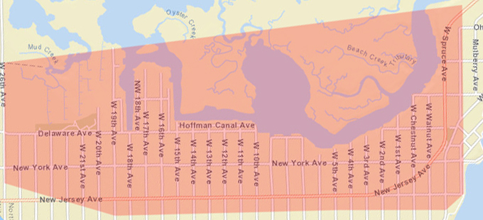
As the last couple of National Weather Service Coastal Flood warnings had tide heights that were under predicted or changed upward at the last minute we decided to update the call area for the Code Red Emergency Notification System. Based on a draft copy of a map produced by the NJDEP utilizing LIDAR surface measurements we expanded the warning area to encompass most of New Jersey Avenue and some sections of side streets in the 100 block East. The old map was based on the areas that received frequent nuisance flooding the new map will include the areas that may receive tidal water during a Moderate flood warning. While the map is based on elevations the area actually flooded depends on many factors such as wind speed, wind direction, timing of wind direction changes associated with the low, operation of tideflex valves, crown height of the N/S streets, if the storm drains are blocked with debris, height of private property bulkheads, rainfall amounts, rate of rainfall, residual water from the last high tide, storm surges caused by a coastal low and rate of rise of the tide. With the expanded area the Code Red flood warning messages will go to 985 more contacts. While most Code Red alerts will be sent for what we categorize as nuisance flooding and will affect only a portion of the call area the expanded area will alert people in those area that may get water.